

news +insights
Update: Isaias Makes Landfall Near Destin as Category 2; 512,000 Lose Power
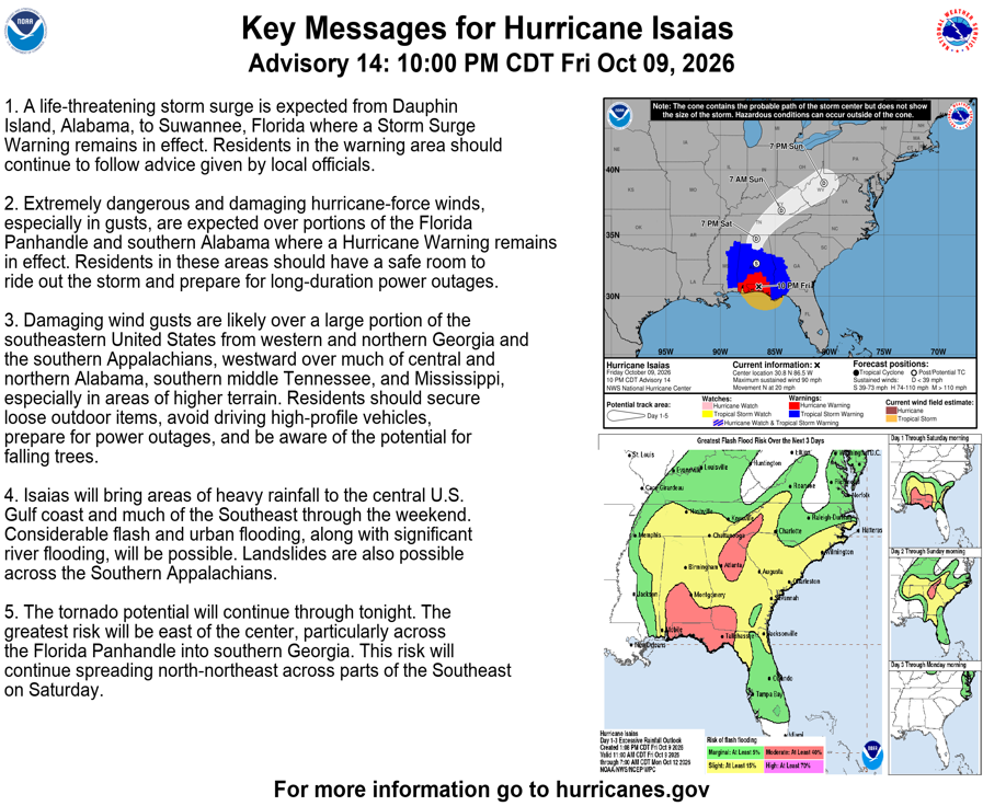
Update: Hurricane Isaias made landfall near Destin, Florida, on Friday night, October 9, as a Category 2 hurricane with winds of about 105 mph, according to the National Hurricane Center. The storm has since weakened to a Category 1 hurricane and is moving north toward Alabama, and more than 512,000 customers in Florida and Alabama have lost power.
This is an update to our earlier report, Isaias Now a 120 MPH Major Hurricane; Panhandle Surge Forecast Raised. What is new: the center is now onshore, the storm came in below the major hurricane strength it held on Friday morning, several coastal warnings west of Alabama have been dropped, and the main hazards are shifting to inland wind, flooding rain and tornadoes. This is a developing story. Damage assessments have not started and the figures below will change.
What Happened
Isaias made landfall at 0130 UTC, which is 8:30 p.m. CDT or 9:30 p.m. EDT on Friday, near Destin in the western Florida Panhandle. The National Hurricane Center put the landfall intensity at 90 knots, or roughly 105 mph, which is Category 2 on the Saffir-Simpson scale (National Hurricane Center). Isaias had briefly reached Category 3 strength earlier on Friday before weakening on approach (CBS News).
By the 10 p.m. CDT advisory the center was inland, about 45 miles east-northeast of Pensacola and about 65 miles northwest of Panama City. Maximum sustained winds had dropped to 90 mph, a Category 1 hurricane, and the minimum central pressure had risen to 982 millibars. The storm was moving north at about 20 mph. Hurricane-force winds extended up to 35 miles from the center and tropical-storm-force winds extended up to 160 miles (National Hurricane Center).
Forecasters said strong wind shear is breaking down the storm's structure and that radar and surface observations near Eglin Air Force Base showed damaging, gusty winds in what remains of the northern eyewall (National Hurricane Center). A wind gust of 112 mph was measured at Santa Rosa Sound, Florida (CBS News).
What Is Confirmed
- Warnings still in effect. A Hurricane Warning runs from the Mississippi/Alabama border to the Bay/Gulf County line in Florida. A Tropical Storm Warning covers the coast east of that line to the Aucilla River. A Storm Surge Warning covers Dauphin Island, Alabama, to the Suwannee River, Florida (National Hurricane Center).
- Warnings dropped. The Hurricane Warning west of the Mississippi/Alabama border, the Tropical Storm Warning west of Ocean Springs, Mississippi, the Storm Surge Warning west of Dauphin Island and the Storm Surge Watch east of the Suwannee River have all been discontinued. With that change, the advisory lists no coastal watch or warning south of the Suwannee River, which includes the Tampa Bay area (National Hurricane Center).
- Storm surge. The remaining surge forecast is 3 to 5 feet above ground from Dauphin Island to the Aucilla River, and 2 to 4 feet from the Aucilla River to the Suwannee River and in Mobile Bay, if peak surge arrives at high tide (National Hurricane Center). Before landfall the forecast was as high as 9 feet between the Alabama/Florida border and Grayton Beach (CBS News). Measured peak water levels have not yet been compiled.
- Rain. Totals of 4 to 8 inches, with isolated amounts up to 15 inches, are forecast across southern Alabama, the Florida Panhandle and Big Bend, and southwest Georgia. Much of the rest of the Southeast is forecast to receive 2 to 5 inches, with up to 10 inches possible in the Southern Appalachians and coastal Carolinas (National Hurricane Center).
- Power. More than 512,000 customers were without power across Florida and Alabama late Friday, based on PowerOutage.us data (CBS News).
- Evacuations and declarations. Officials said tens of thousands of people evacuated, with orders covering parts of Okaloosa and Walton counties in Florida. Governor Ron DeSantis declared a state of emergency for more than two dozen Florida counties, Alabama Governor Kay Ivey did so for 40 counties, Georgia Governor Brian Kemp also declared an emergency, and federal emergency declarations were approved for Florida and Alabama (CBS News).
What Is Not Yet Known
Landfall came after dark, and there is no official damage assessment yet for buildings, roads, bridges, ports or utilities in the Destin, Fort Walton Beach and Pensacola areas. The sources reviewed for this report did not include any confirmed figures for deaths or injuries. Restoration timelines for power have not been published. Outage counts were still changing late Friday as the wind field moved inland, so the half-million figure should be read as a snapshot.
Where the Storm Goes Next
The National Hurricane Center expects Isaias to keep moving north through Saturday, cross Alabama, and then turn northeast into the Tennessee Valley on Sunday. The forecast calls for 60 mph winds over central Alabama by Saturday morning, by which point Isaias is expected to be a post-tropical system, followed by 35 mph winds over northern Alabama by Saturday evening and dissipation by Monday morning (National Hurricane Center).
Weaker sustained winds do not mean the wind threat is over. Forecasters said hurricane-force winds, mainly in gusts, could reach as far as 100 miles inland into southern Alabama, and that damaging gusts are likely through Saturday across central and northern Alabama, western and northern Georgia, the southern Appalachians, southern middle Tennessee and Mississippi, especially on higher ground. The tornado risk continues overnight across the Florida Panhandle, north Florida and southern Georgia, and extends into Georgia and the Carolinas on Saturday (National Hurricane Center).
What It Means for Owners and Contractors
- Stay off Panhandle sites until officials clear access. Surge and hurricane warnings are still active from Alabama to the Bay/Gulf County line. Downed lines, standing water and blocked roads are the main hazards in the first day after landfall, and re-entry timing is set by county emergency managers, not project schedules.
- Inspect before restarting. Tower cranes, hoists, scaffolding, shoring, temporary bracing, formwork and partially enclosed structures should be inspected by qualified personnel before work resumes. Excavations and trenches that took on water need to be checked for wall stability before anyone enters.
- Document conditions first. Photograph and log site conditions, stored materials and equipment before cleanup begins. That record supports builder's risk claims and any request for a time extension.
- Send notices on time. Most construction contracts require written notice of a weather or force majeure delay within a set number of days. Owners and contractors with projects in the affected counties should check those clauses now, since the notice clock usually starts with the event.
- Plan for inland exposure on Saturday. Projects in Alabama, Georgia and Tennessee that were outside the coastal warning area still face damaging gusts and heavy rain. Securing loose material, lowering crane booms where the manufacturer calls for it, and protecting open excavations remain relevant there through Saturday.
- Expect short-term pressure on labor and materials. Large outage counts after a landfall typically pull electrical crews, roofers, generators and fuel toward restoration and repair work in the weeks that follow. Projects elsewhere in Florida and the Southeast should confirm delivery dates and subcontractor availability.
- Tampa Bay and St. Petersburg. No coastal watch or warning is listed for the Tampa Bay area in the latest advisory. Swells from the storm are still producing dangerous surf and rip currents along the Gulf coast, which matters for marine and shoreline work.
What to Watch
- The next full National Hurricane Center advisory at 4 a.m. CDT Saturday, and when the remaining surge and hurricane warnings are lifted.
- First-light damage assessments from Okaloosa, Walton, Santa Rosa and Escambia counties, including bridge and road status.
- Utility restoration estimates for the Panhandle and southern Alabama.
- Flash flood and river flood reports as the heaviest rain moves through Alabama and Georgia.
- Any state or federal major disaster declaration, which would open recovery funding and public assistance work.
One historical note: Isaias became a hurricane on October 7, the latest date for an Atlantic season's first hurricane in 121 years (CBS News).
Image credit: National Hurricane Center. Image from the source article.
Sources
- National Hurricane Center, Hurricane Isaias Discussion Number 14: https://www.nhc.noaa.gov/text/refresh/MIATCDAT4+shtml/100246.shtml
- National Hurricane Center, Hurricane Isaias Advisory Number 14: https://www.nhc.noaa.gov/text/refresh/MIATCPAT4+shtml/100245.shtml
- CBS News, Hurricane Isaias makes landfall on Gulf Coast. See maps, forecast path.: https://www.cbsnews.com/news/hurricane-isaias-first-storm-2026-atlantic-season-record/



Let's connect
For organizations planning commercial, industrial, or infrastructure work, we will review the project and recommend the appropriate delivery approach.

Join our team
If you hold yourself to careful, accountable work, you already work the way we do.