

news +insights
Update: Isaias Now a 120 MPH Major Hurricane; Panhandle Surge Forecast Raised
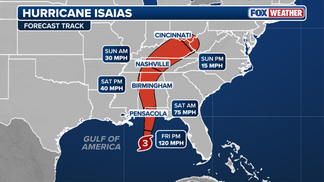
Update: Hurricane Isaias became a major hurricane on Friday morning, with maximum sustained winds of 120 mph, and the National Hurricane Center has raised its peak storm surge forecast to 6 to 9 feet for the western Florida Panhandle. Landfall is expected within the Hurricane Warning area tonight or early Saturday.
This is an update to our earlier report, Isaias Reaches 100 MPH as Florida Panhandle Counties Order Evacuations. What is new: the storm has passed the 110 mph peak that forecasters projected on Thursday, the surge forecast for the stretch from the Alabama/Florida border to Grayton Beach is higher, and tropical storm conditions are due on the coast within hours. This is a developing story and the figures below will change with each advisory.
What Happened
At 7:20 a.m. CDT on Friday, October 9, the National Hurricane Center issued a special update stating that Isaias had become a major hurricane. An Air Force Reserve Hurricane Hunter aircraft found maximum sustained winds of 120 mph, and a dropsonde measured a minimum central pressure of 959 millibars. The center was about 240 miles south of Pensacola and about 170 miles south-southeast of the mouth of the Mississippi River, moving north-northeast at 15 mph (National Hurricane Center). Winds of 120 mph fall in Category 3 on the Saffir-Simpson scale.
The update came 20 minutes after the 7 a.m. CDT intermediate advisory, which carried winds of 110 mph and said Isaias was on the cusp of major hurricane strength. That advisory told people in the Storm Surge and Hurricane Warning areas that preparations should be finished within the next few hours (National Hurricane Center).
The strengthening happened overnight. In the 4 a.m. CDT forecast discussion, forecasters reported that NOAA and Air Force Reserve aircraft had measured flight-level winds of 107 knots, and that the eye had become better defined while the eyewall contracted (National Hurricane Center).
What Is Confirmed
Watches and warnings did not change with the 7 a.m. CDT advisory (National Hurricane Center):
- Hurricane Warning: Ocean Springs, Mississippi, to the Bay/Gulf County line, Florida.
- Storm Surge Warning: mouth of the Mississippi River to the Suwannee River, Florida.
- Tropical Storm Warning: the Jefferson/Plaquemines Parish line in Louisiana to west of Ocean Springs, and east of the Bay/Gulf County line to the Aucilla River, Florida.
- Storm Surge Watch: Suwannee River to Yankeetown, Florida. No watch or warning is listed for the Tampa Bay coastline.
The storm surge forecast was corrected and raised in that advisory. Heights are above ground, and assume peak surge arrives at high tide (National Hurricane Center):
- Alabama/Florida border to Grayton Beach, Florida: 6 to 9 feet. Our previous report had 5 to 7 feet for this area.
- Grayton Beach to Indian Pass, Florida: 4 to 7 feet.
- Dauphin Island, Alabama, to the Alabama/Florida border: 4 to 6 feet.
- Indian Pass to the Steinhatchee River, Florida: 4 to 6 feet.
- Steinhatchee River to the Suwannee River, Florida: 3 to 5 feet.
- Mouth of the Mississippi River to Dauphin Island, and Mobile Bay: 3 to 5 feet.
- Suwannee River to Yankeetown, Florida: 2 to 4 feet.
Other hazards and timing in the same advisory:
- Wind field: hurricane force winds extend up to 30 miles from the center, and tropical storm force winds extend up to 185 miles.
- Timing: tropical storm conditions begin in the warning areas within hours of the advisory, with hurricane conditions tonight into early Saturday. The storm is expected to turn north later today and approach the coast this afternoon.
- Rain: 4 to 8 inches, with local totals up to 15 inches, across southern Alabama, the Florida Panhandle and Big Bend, and southwest Georgia through the weekend. Elsewhere in the Southeast, 2 to 5 inches, with local totals up to 10 inches in the southern Appalachians and coastal Carolinas. Flash and urban flooding is likely and river flooding could be significant.
- Tornadoes: the risk begins late this afternoon along coastal Alabama, the Florida Panhandle and far southwest Georgia, and extends on Saturday to parts of eastern Alabama, Georgia and the Carolinas.
State and private sector actions reported by FOX Weather as of 9:57 a.m. EDT Friday:
- The governors of Florida, Alabama and Georgia have declared states of emergency.
- Evacuation orders are in effect in Escambia, Okaloosa and Walton counties in Florida and on Dauphin Island, Alabama. Orange Beach, Alabama, has ordered coastal tourists and visitors to leave.
- School districts in more than a dozen Florida and Alabama counties canceled classes through the end of the week.
- NOAA's Weather Prediction Center has posted a Level 3 of 4 flash flood risk for Mobile and the Florida Panhandle west of Panama City.
- Offshore operators have reduced activity. Shell began shut-in procedures at five offshore facilities, and Chevron and BP removed non-essential workers.
What Is Not Yet Known
- Intensity at landfall. The 4 a.m. CDT discussion forecast a high-end Category 2 hurricane at the coast, because wind shear is expected to increase sharply before landfall. Forecasters called the situation delicate and said a delay of about six hours in the shear would bring a stronger hurricane ashore (National Hurricane Center). That discussion was written before the storm reached 120 mph.
- The landfall point. The National Hurricane Center says only that landfall will be within the Hurricane Warning area. FOX Weather's forecast places it between Pensacola and Destin between 9 p.m. and midnight EDT (FOX Weather). That is an outlet forecast, not an official one.
- Local closures. We have not confirmed the current status of ports, airports, bridges or utility staging for this report.
What It Means for Owners and Contractors
- The preparation window is closing or closed. With tropical storm force winds reaching 185 miles from the center, conditions on the coast will deteriorate well before the eye arrives. Crews should not be on sites in evacuation zones, and no one should attempt crane, scaffold or roof work in rising wind.
- Review surge exposure against the new numbers. A forecast of 6 to 9 feet above ground between the state line and Grayton Beach covers Pensacola Beach, Navarre, Fort Walton Beach, Destin and the western end of the Walton County coast. Owners with ground-level electrical gear, stored materials or equipment in that stretch should assume a higher water line than Thursday's forecast implied.
- Expect a wide wind footprint. The forecast discussion says the wind field will expand as the storm interacts with an upper trough, and that damaging gusts are possible across central and northern Alabama, eastern Mississippi and western and northern Georgia (National Hurricane Center). Inland sites should secure loose material, lower or tie off what can move, and check erosion controls.
- Plan for long power outages. The National Hurricane Center tells residents in the Hurricane Warning area to prepare for long-duration outages. Temporary power, fuel, dewatering and drying equipment will be in short supply locally, so arrange them from outside the impact area.
- Keep the paper trail current. The 7:20 a.m. CDT update, the evacuation orders and the emergency declarations are dated public records. Save them with pre-storm photos and daily reports to support weather delay notices and builder's risk claims.
- Tampa Bay and west central Florida: the coast remains outside all watches and warnings, with the Storm Surge Watch ending at Yankeetown in Levy County. Deliveries and crews moving through the Interstate 10 corridor should expect disruption through the weekend.
What to Watch
- The complete advisory due at 10 a.m. CDT Friday and the intermediate advisories that follow.
- Whether shear weakens Isaias before landfall, or whether it comes ashore as a major hurricane.
- Any shift in the track, which moves the zone of highest surge.
- Re-entry rules, bridge reopenings and damage assessments from county emergency management after landfall.
Use the latest products from the National Hurricane Center, your local National Weather Service office and county emergency management for decisions, not this summary.
Image credit: FOX Weather. Image from the source article.
Sources
- National Hurricane Center, Hurricane Isaias Tropical Cyclone Update, 7:20 AM CDT October 9: https://www.nhc.noaa.gov/text/refresh/MIATCUAT4+shtml/091220.shtml
- National Hurricane Center, Hurricane Isaias Intermediate Advisory Number 11A (Corrected): https://www.nhc.noaa.gov/text/refresh/MIATCPAT4+shtml/091157.shtml
- National Hurricane Center, Hurricane Isaias Discussion Number 11: https://www.nhc.noaa.gov/text/refresh/MIATCDAT4+shtml/090858.shtml
- FOX Weather, Hurricane Isaias explodes into monster Cat 3 storm as Gulf Coast residents urged to finish preparations: https://www.foxweather.com/weather-news/isaias-first-atlantic-hurricane-threatening-gulf-coast




Let's connect
For organizations planning commercial, industrial, or infrastructure work, we will review the project and recommend the appropriate delivery approach.

Join our team
If you hold yourself to careful, accountable work, you already work the way we do.