

news +insights
Update: Isaias Reaches 100 MPH as Florida Panhandle Counties Order Evacuations

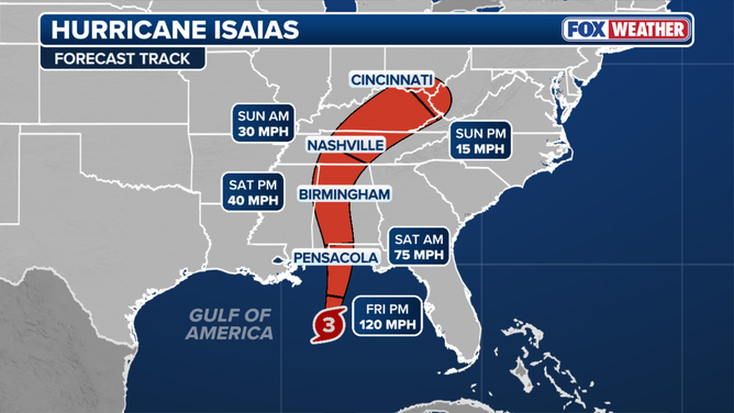
Update: Hurricane Isaias has strengthened to 100 mph sustained winds in the Gulf, and evacuation orders are now in effect across the Florida Panhandle, including Escambia, Okaloosa, Walton and Franklin counties. The National Hurricane Center still expects landfall on the northern Gulf Coast late Friday or early Saturday, with tropical storm conditions arriving in the warning areas on Friday.
This is an update to our earlier report, Isaias Becomes Hurricane; Warnings Issued for Florida Panhandle. What is new: the storm is stronger, the Storm Surge Warning now reaches east to the Suwannee River, the rainfall forecast has been raised, and county evacuation orders that we could not confirm in that post are now in effect. This is a developing story and details will change with each advisory.
What Happened
At 7 p.m. CDT (8 p.m. EDT) on Thursday, October 8, the National Hurricane Center placed Isaias about 290 miles south of the mouth of the Mississippi River with maximum sustained winds of 100 mph and a minimum central pressure of 974 millibars, moving northeast at 13 mph (National Hurricane Center). Winds of 100 mph fall in Category 2 on the Saffir-Simpson scale. The agency raised its intensity estimate to 85 knots in its 4 p.m. CDT forecast discussion, based on aircraft radar data, and noted that Isaias has developed the first eye seen in the Atlantic basin this season (National Hurricane Center).
County governments in Northwest Florida acted ahead of the storm. Evacuation orders took effect at noon Thursday in Escambia, Okaloosa, Walton and Franklin counties (City of Pensacola, WJHG).
What Is Confirmed
Evacuation orders and local closures:
- Escambia County: evacuation ordered for Zones A and B, which cover Perdido Key, Innerarity Point, Pensacola Beach and other low-lying areas, plus anyone in a mobile home or low-lying area regardless of zone. Two shelters opened at 3 p.m. Thursday (City of Pensacola).
- Okaloosa County: mandatory evacuation of Zones A and B, covering Okaloosa Island and coastal parts of Fort Walton Beach, Destin, Mary Esther and Niceville. The county declared a local state of emergency for seven days, scheduled all three county airports to close at 9 p.m. Thursday, and closed county offices for Friday (Get The Coast).
- Walton County: mandatory evacuation of Zones A, B and C, driven by storm surge of up to 7 feet (WJHG).
- Franklin County: mandatory evacuation of all barrier islands, Alligator Point, Bald Point, low-lying areas, mobile homes and RV parks. Bridges will close to all vehicles once sustained winds reach 45 mph, and county offices are closed Friday (WJHG).
- Bay County: voluntary evacuation for Zones A and B and for mobile and manufactured home residents countywide. Gulf County: mandatory evacuation limited to RVs at three named parks and campgrounds (WJHG).
- Military installations: Eglin Air Force Base issued a limited evacuation order for personnel living in the affected county zones, and Hurlburt Field ordered about 1,000 residents of base housing and its RV park to leave by 5 p.m. Thursday (WJHG).
Watches and warnings as of the 7 p.m. CDT advisory (National Hurricane Center):
- Hurricane Warning: Ocean Springs, Mississippi, to the Bay/Gulf County line, Florida. This is unchanged.
- Storm Surge Warning: mouth of the Mississippi River to the Suwannee River, Florida. Our previous report had the eastern end at the Steinhatchee River.
- Tropical Storm Warning: the Jefferson/Plaquemines Parish line in Louisiana to west of Ocean Springs, and east of the Bay/Gulf County line to the Aucilla River, Florida.
- Storm Surge Watch: Suwannee River to Yankeetown, Florida. No watch or warning is listed for the Tampa Bay coastline.
Forecast hazards and timing:
- Intensity: some further strengthening is expected overnight, with a forecast peak of 95 knots (110 mph) early Friday. Increasing wind shear is expected to weaken the storm somewhat as it nears the coast, but forecasters say it will remain a dangerous hurricane through landfall (National Hurricane Center).
- Timing: tropical storm conditions begin Friday in the warning areas, with hurricane conditions Friday night into early Saturday (National Hurricane Center).
- Storm surge: 5 to 7 feet above ground from Ocean Springs to Indian Pass, Florida, including Mobile Bay, if peak surge arrives at high tide. 4 to 6 feet from Indian Pass to the Steinhatchee River, and 2 to 4 feet from the Suwannee River to Yankeetown (National Hurricane Center).
- Rain: 4 to 8 inches, with local totals up to 15 inches, across southern Alabama, the Florida Panhandle and Big Bend, and southwest Georgia from Friday through the weekend. That is higher than the 3 to 7 inches in our previous report (National Hurricane Center).
- Inland wind: damaging gusts are possible across central and northern Alabama, extreme eastern Mississippi, and western and northern Georgia, and more watches and warnings may be issued (National Hurricane Center).
What Is Not Yet Known
- The exact landfall point and intensity. The latest forecast track was nudged slightly east and brings the center inland along the northern Gulf Coast within about 36 hours of the 4 p.m. CDT discussion (National Hurricane Center).
- Whether evacuation zones will be expanded, and when individual bridges will close. Franklin County has published a 45 mph threshold. We have not confirmed thresholds or closure times for bridges in other counties.
- The status of ports, airports outside Okaloosa County and utility service. We have not confirmed those for this report.
What It Means for Owners and Contractors
For projects inside the evacuation zones, the window for site work has closed. The priority now is people, then documentation, then recovery planning.
- Do not send crews into ordered evacuation zones. Site securement that was not finished before the orders took effect should not be attempted once tropical storm force winds arrive on Friday. Confirm that every employee and subcontractor crew has been released and accounted for.
- Record site conditions now. If it can be done safely and legally, keep dated photos, daily reports and delivery records showing the state of the work before the storm. They support builder's risk claims and schedule extension requests.
- Send weather and force majeure notices on time. Many contracts start the notice clock at the event, not at the discovery of damage. Evacuation orders and government closures are dated public records that help document the delay.
- Plan for delayed re-entry. Bridge closures, flooding, debris and power outages can keep crews off barrier island and coastal sites for days. Line up pumps, generators, fuel, temporary roofing and drying equipment from outside the impact area.
- Inspect before restarting. Have cranes, hoists, scaffolding, shoring, excavations and temporary electrical systems inspected by qualified people before work resumes. Treat standing water and downed lines as hazards.
- Watch inland projects too. With up to 15 inches of rain possible locally and damaging gusts forecast well inland, sites in Alabama and Georgia should secure loose material and check erosion controls and dewatering.
- Tampa Bay and west central Florida: no coastal watch or warning is posted, and the Storm Surge Watch ends at Yankeetown in Levy County. Projects that depend on deliveries or crews moving through the Interstate 10 corridor should expect disruption.
What to Watch
- The next complete advisory at 10 p.m. CDT Thursday and those that follow on Friday (National Hurricane Center).
- Whether Isaias reaches its forecast 110 mph peak and how much it weakens before landfall.
- Any further shift in the track, which moves the zone of highest surge.
- New or expanded evacuation orders, bridge closures and re-entry rules from county emergency management offices.
Use the latest products from the National Hurricane Center, your local National Weather Service office and county emergency management for decisions, not this summary.
Image credit: Sean Foster via Unsplash. Stock photo of palm trees in strong wind, not an image of Hurricane Isaias or of any affected area.
Sources
- National Hurricane Center, Hurricane Isaias Intermediate Advisory Number 9A: https://www.nhc.noaa.gov/text/refresh/MIATCPAT4+shtml/082351.shtml
- National Hurricane Center, Hurricane Isaias Discussion Number 9: https://www.nhc.noaa.gov/text/refresh/MIATCDAT4+shtml/082100.shtml
- City of Pensacola, Escambia County Issues Evacuation Order for Zones A and B Due to Hurricane Isaias: https://www.cityofpensacola.com/m/newsflash/Home/Detail/5231
- Get The Coast, Okaloosa County declares state of emergency, orders mandatory evacuation of Zones A and B ahead of Isaias: https://getthecoast.com/okaloosa-county-declares-state-of-emergency-orders-mandatory-evacuation-of-zones-a-and-b-ahead-of-isaias/
- WJHG, Evacuation orders, shelters announced across Northwest Florida ahead of Hurricane Isaias: https://www.wjhg.com/2026/10/08/evacuation-orders-shelters-announced-across-northwest-florida-ahead-hurricane-isaias/



Let's connect
For organizations planning commercial, industrial, or infrastructure work, we will review the project and recommend the appropriate delivery approach.

Join our team
If you hold yourself to careful, accountable work, you already work the way we do.