

news +insights
Update: Isaias Becomes Hurricane; Warnings Issued for Florida Panhandle

Update: Isaias became a hurricane late Wednesday night in the Gulf, and the National Hurricane Center has replaced its coastal watches with a Hurricane Warning from Ocean Springs, Mississippi, to the Bay/Gulf County line in Florida and a Storm Surge Warning from the mouth of the Mississippi River to the Steinhatchee River in Florida. Landfall is forecast on the northern Gulf Coast late Friday night or early Saturday.
This is an update to our earlier report, Hurricane, Storm Surge Watches Issued for Florida Panhandle Ahead of Isaias. What is new: the watches described in that post are now warnings, the storm has reached hurricane strength, and the forecast peak intensity has been set at 110 mph. This is a developing story and the forecast will change with each advisory.
What Happened
At 10 p.m. CDT (11 p.m. EDT) on Wednesday, October 7, the National Hurricane Center issued Advisory 6 on Isaias with new warnings for the northern Gulf Coast (National Hurricane Center). At that time Isaias was still a tropical storm with maximum sustained winds of 70 mph, centered about 460 miles south-southwest of the mouth of the Mississippi River and moving east-northeast at 9 mph (National Hurricane Center).
Shortly afterward, the agency's website listed the system as Hurricane Isaias, with maximum sustained winds of 75 mph and a minimum central pressure of 982 millibars as of 10:30 p.m. CDT (National Hurricane Center).
What Is Confirmed
The following watches and warnings were in effect as of Advisory 6 (National Hurricane Center):
- Hurricane Warning: Ocean Springs, Mississippi, to the Bay/Gulf County line, Florida. The agency says a Hurricane Warning means "hurricane conditions are expected somewhere within the warning area."
- Storm Surge Warning: mouth of the Mississippi River to the Steinhatchee River, Florida.
- Tropical Storm Warning: the Jefferson/Plaquemines Parish line in Louisiana to west of Ocean Springs, and east of the Bay/Gulf County line to the Aucilla River, Florida.
- Storm Surge Watch: Steinhatchee River to Yankeetown, Florida.
The advisory does not list any watch or warning for the Tampa Bay coastline. Yankeetown, in Levy County, is the southern end of the Storm Surge Watch.
Forecast timing and intensity:
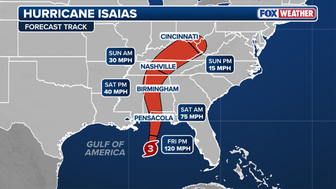
- Isaias is expected to turn northeast and then north on Thursday and Friday, and to make landfall within the warning area late Friday or early Saturday (National Hurricane Center).
- The official forecast calls for peak winds of 95 knots (110 mph) on Friday morning, easing slightly to 90 knots (105 mph) by Friday evening as wind shear increases near the coast (National Hurricane Center).
- Forecasters say rapid intensification is possible because the storm is small and is building an inner core over very warm water, and they describe their intensity forecast as being at the high end of the model guidance (National Hurricane Center).
- Tropical storm conditions are expected to begin in the warning areas on Friday, with hurricane conditions Friday night into early Saturday (National Hurricane Center).
Expected hazards (National Hurricane Center):
- Storm surge: 5 to 7 feet above ground from Ocean Springs to Indian Pass, Florida, including Mobile Bay, if peak surge arrives at high tide. 4 to 6 feet from Indian Pass to the Steinhatchee River. 3 to 5 feet from the mouth of the Mississippi River to Ocean Springs. 2 to 4 feet from the Steinhatchee River to Yankeetown.
- Rain: 3 to 7 inches, with local totals up to 10 inches, from far southeastern Louisiana to the Florida Panhandle from Friday through the weekend. 1 to 3 inches, locally up to 5, across much of the Southeast north to the Tennessee Valley and the Carolinas.
- Tornadoes: isolated tornadoes are possible Friday night in coastal Alabama and the Florida Panhandle, and on Saturday in eastern Alabama, western Georgia and the Panhandle.
The forecast discussion also states that gusty winds should extend well inland after landfall because the wind field is expanding and the storm will be moving quickly, and it tells residents in the Hurricane Warning area to prepare for long power outages (National Hurricane Center).
What Is Not Yet Known
- The exact landfall point. The warning area spans the Mississippi, Alabama and Florida Panhandle coasts, and the agency notes the deepest surge is expected near and east of where the center comes ashore.
- How strong Isaias will be at landfall. Forecasters note that some models are faster and farther east than others, and that the inland track was shifted west in this advisory (National Hurricane Center).
- Local evacuation orders, closures and emergency declarations. We have not confirmed any for this report. Check county emergency management offices directly.
What It Means for Owners and Contractors
A warning is a shorter clock than a watch. With tropical storm conditions expected in the warning areas on Friday, Thursday is the last full working day to secure most sites from coastal Mississippi through the Florida Panhandle. Work that requires cranes, lifts or people at height should be planned around the arrival of tropical storm force winds, not the landfall time.
- Finish site securement on Thursday. Follow manufacturer procedures for tower cranes and hoists, lower booms, and tie down or remove loose material, scaffolding planks, fencing screens, portable toilets and dumpsters.
- Plan for water as well as wind. In surge warning zones, move equipment, stored material, fuel and temporary power to higher ground. Inland, check dewatering pumps, erosion controls and open excavations ahead of 3 to 7 inches of rain.
- Protect work in place. Close openings in building envelopes, protect roof work in progress, and photograph site conditions before and after the storm for insurance and schedule records.
- Review contracts and coverage now. Check notice deadlines for weather delay and force majeure claims, named storm deductibles on builder's risk policies, and who is responsible for securing owner furnished material.
- Expect supply and labor disruption. Power outages, port and road closures, and evacuations can delay deliveries and crews for days after landfall, including on projects outside the direct impact area that draw material through northern Gulf ports or the Interstate 10 corridor.
- Tampa Bay and west central Florida: no warnings are posted, but sites north along the Nature Coast are inside the Storm Surge Watch. Keep monitoring, since the agency notes its track forecast sits on the eastern side of the guidance.
What to Watch
- The next complete advisory at 4 a.m. CDT (5 a.m. EDT) Thursday, with intermediate advisories in between (National Hurricane Center).
- Whether Isaias intensifies faster than forecast on Thursday.
- Any east or west shift in the track, which would move the zone of highest surge and strongest wind.
- Evacuation orders and emergency declarations from state and county officials.
Use the latest products from the National Hurricane Center and your local National Weather Service office for decisions, not this summary.
Image credit: Dylan Frank via Unsplash. Stock photo of a construction crane under a dark sky, not an image of Hurricane Isaias or of any affected site.
Sources
- National Hurricane Center, Isaias Public Advisory Number 6: https://www.nhc.noaa.gov/text/refresh/MIATCPAT4+shtml/080251.shtml
- National Hurricane Center, Isaias Forecast Discussion Number 6: https://www.nhc.noaa.gov/text/refresh/MIATCDAT4+shtml/080253.shtml
- National Hurricane Center, Atlantic tropical cyclone status page: https://www.nhc.noaa.gov/



Let's connect
For organizations planning commercial, industrial, or infrastructure work, we will review the project and recommend the appropriate delivery approach.

Join our team
If you hold yourself to careful, accountable work, you already work the way we do.